Sanyaa and Taant’a Kwáans: Saxman/Ketchikan/Cape Fox
The following is a list of locations within the Sanyaa and Taant’a Kwáan territories that were identified as notable herring spawning and massing areas during individual interviews and focus group interviews conducted during this synthesis project and in previously documented research efforts: Badger Bay, Behm Canal, Betton Island, Blank Inlet, Blank Islands, Boca de Quadra, California Head, Carroll Inlet, Cat Island, City Float, Clover Pass, Foggy Bay, Fox Island, George Inlet, Gravina Island, Herring Cove, Kah Shakes, Ketchikan Harbor, Knudsen Cove, Loring Cannery, Lucky Cove, Mary Island, Mountain Point, Point McCartey, Sargent Bay, Saxman Village, Spacious Bay, Thomas Basin, Thorne Arm, Thorne Bay, Tongass Narrows, Totem Bight, Walker Cove, Ward Cove, Weasel Cove, Wistanley Island, Yes Bay/Why Bay.
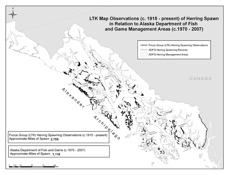
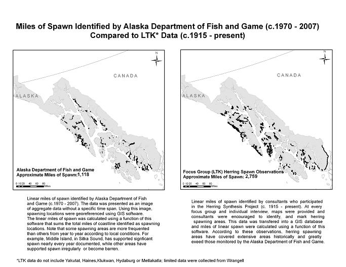
Click here to view map
Hinyaa Kwáan: Craig/Klawock/Hydaburg
The following is a list of locations within the Hinyaa Kwáan that were identified as notable herring spawning and massing areas during individual interviews and focus group interviews conducted during this synthesis project and in previous research efforts: Abbess Island, Alberto Islands, (Bartolome) Baker Island, Clam Island, Craig/Klawock, Eagle Island, Edna Bay, Fern Point, Fish Egg Island, Fox Island (Belanny Islands), Graveyard (Pitt) Island, Klawock River, Klawock Harbor, Kosciusko Island, Marble Island, Meares Passage, Noyes Island, Point Baker, Port Protection, Portillo Channel, Prince of Wales Island, Rocky Cove, San Fernando Island, San Juan Bautista Island, St. Joseph Island, Steamboat Bay, Tokeen area, Tonowek Narrows, Turn Point, Wadleigh Island, Warm Chuck Inlet, and Warren Channel
.
Click here to view map.
Shtax’héen Kwáan: Wrangell
The following is a list of locations within the Shtax’héen Kwáan, that were identified as notable herring spawning and massing areas during individual interviews and focus group interviews conducted during this synthesis project and in previously documented research efforts: Anan Creek, Anita Bay, Blake Channel, Bond Bay, Bradfield Canal, Caamano Point, Cleveland Peninsula, Deep Bay, Deer Island, Elephants Nose, Etolin Island, Farragut Bay, Helm Bay, Ideal Cove, Meyer’s Chuck, Olive Cove, Petersburg, Point Stewart, Quiet Harbor, Roosevelt Bay, Scow Bay, Snow Pass, Steamer Bay, Sumner Strait, Sunny Bay, Thomas Bay, Totem Bay, Union Bay, Woronkofski Island, Wrangell Harbor, Wrangell Narrows, Zimovia Straits
Click here to view map
Kéex’ and Kooyú Kwáans: Kake/Kuiu
The following is a list of locations within the Kéex’ and Kooyú Kwáans, that were identified as notable herring spawning and massing areas during individual interviews and focus group interviews conducted during this synthesis project and in previously documented research efforts: Affleck Canal, Big Creek, Big John Bay, Cape Bendel, Chatham Strait, Conclusion Island, Dakaneek Bay, Deep Cove, Frederick Sound, Gedney Harbor, Gil Harbor, Halleck Harbor, Hamilton Bay, Kadake Bay, Kake, Keku Islands, Kuiu Island, Monte Carlo Island, No Name Bay, Pillar Bay, Pinta Point, Point Barrie, Port Armstrong, Port Beauclerc, Port Camden, Port Conclusion, Port Herbert, Port Houghton, Port Lucy, Port Malmsbury, Portage Bay, Pybus Bay, Rocky Pass Inlet, Rowan Bay, Saginaw Bay, Salt Lake, Security Bay, Table Bay, Tebenkof Bay, Threemile Arm, Turnabout Island, and Washington Bay
Click here to view map
Xutsnoowú Kwáan: Angoon
The following is a list of locations within the Xutsnoowú Kwáan, that were identified as notable herring spawning and massing areas during individual interviews and focus group interviews conducted during this synthesis project and in previously documented research efforts: Admiralty Island, Angoon, Cedar Point, Chatham Strait, Danger Point, Distant Point, East Point, Eliza Harbor, Favorite Bay, Graveyard Island, Gut Bay, Hood Bay, Kelp Bay, Killisnoo Island, Kootznahoo Inlet, Mitchell Bay, Murder Cove, Peril Strait, Point Gardner, Point Samuel, Pond Island, Sitkoh Bay, Tenakee Inlet (Long Bay, Saltery Bay, Seal Bay), and Tyee.
Click here to view map
Sheet’ka Kwáan: Sitka
The following is a list of locations within the Sheet’ka Kwáan, that were identified as notable herring spawning and massing areas during individual interviews and focus group interviews conducted during this synthesis project and in previously documented research efforts: Aleutkina Bay, Apple Islands, Bieli Rocks, Big Bay, Big Port Walter, Biorka Island, Camp Coogan Bay, Cape Edgecumbe, Cape Ommaney, Cedar Cove, Cedar Pass, Chaichei Islands, Crawfish Bay, Crawfish Inlet, Crow Island, Deep Inlet, Dog Point, Dorothy Narrows, Fish Bay, Freds Creek, Gagarin Island, Gavanski Islands (Big and Little), Goddard, God’s Pockets, Halibut Point, Herring Rock, Howard Strait, Hot Springs Bay, Jamestown Bay, Japonski Island, Kasiana Islands, Katlian Bay, Krestof Island, Kruzof Island, Larch Bay, Lava Island, Leesofftskaia Bay, Middle Island, Nakwasina Bay, Nakwasina Sound, Necker Bay, No Thorofare Bay, Parker Group, Partofshikof Island,
Patterson Bay, Peril Straits, Pirates Cove, Point Brown, President Bay, Promisla Cove, Redoubt, Saint Lazaria Island, Salsibury Sound, Samsing Cove, Sandy Cove, Sealing Cove, Shelikof Bay, Shoals Point, Siginaka Islands, Silver Bay, Silver Point, Sinitsin Cove, Sinitsin Island, Slocum Arm, Sitka Area (the Cove Dock, the Cape Area, Sitka Sound, Sitka Harbor, in front of Sitka Village, Old Sitka), St. John Baptist Bay, Sukoi Inlet, Three Entrance Bay, Ushk Bay, West Crawfish Inlet/Windy Passage, Whale Bay, Whiting Harbor, Windy Pass, and Yamani Island.
Click here to view map
Áak’w and T’aaku Kwáans: Juneau/Douglas
The following is a list of locations within the Áak’w and T’aaku Kwáans, that were identified as notable herring spawning and massing areas during individual interviews and focus group interviews conducted during this synthesis project and in previously documented research efforts: Auke Bay, Benjamin Island, Berners Bay, Bridget Cove, Douglas Island, Eagle River, Echo Cove, Funter Bay, Gambier Bay, Hawk Inlet, Hobart Bay, Indian Cove, Juneau Harbor, Lynn Canal, Middle Point, Piling Point, Point Louisa, Portland Island, Seymour Canal, Stephens Passage, Windham Bay, Winning Cove, Yankee Cove.
Click here to view map
Xunaa Káawu: Hoonah
The following is a list of locations within the Xunaa Káawu, that were identified as notable herring spawning and massing areas during individual interviews and focus group interviews conducted during this synthesis project and in previously documented research efforts: Bell Island, Burnt Point, Cedar Point, Chimney Rock, Dundas Bay, Dundas River, Eight Fathom Bight, Elfin Cove, Excursion Inlet, False Bay, Fingers Bay, Flynn Cove, Freshwater Bay, Gallagher Creek, Game Creek, Gartina Creek, Glacier Bay (Willoughby Island), Grassy Island, Graves Harbor, Graveyard Island, Hoonah Harbor, Hoonah Island, Icy Strait, Idaho Inlet, Inian Point, Lisianski Inlet, Long Island, Neka Bay, Pelican Harbor, Pinta Cove, Pint Rock, Pleasant Island, Point Adolphus, Point Augusta, Port Frederick, Sawmill Bay, Shaw Island, Taylor Bay, The Sisters, Whitestone Harbor, Willoughby Island, Yakobi Island.
Click here to view map


